Related Articles


The first significant winter storm of the year may bring with it a lot of rain, ice, and snow.
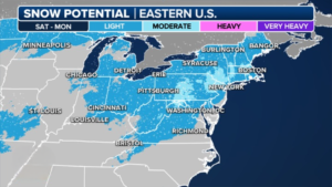
This weekend, a developing winter storm may have a significant impact on major East Coast cities, possibly breaking record snowless streaks of over 700 days in some of them.
It is anticipated that on Friday, an area of low pressure will develop close to the Gulf Coast and move up the East Coast over the course of the weekend, affecting the states of Texas through Maine.
The exact amount of snowfall is still unknown because the location of this low-pressure system will be critical to the forecast, even though several inches of rain are possible for portions of the Southeast.
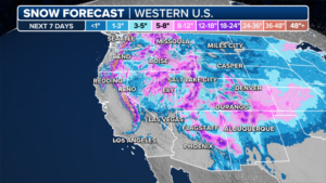
A string of storms will batter the West Coast.
Several strong storms bringing feet of mountain snow and torrential rain are aimed at the western United States.
There’s a chance of up to three feet of snow in certain areas of the Californian Sierra Nevada mountains, and higher Cascade elevations in Washington and Oregon may see even more snowfall.
Overnight, the Quadrantids meteor shower peaks.
The Quadrantid meteor shower, which is regarded as one of the best of the year, peaks tonight. You won’t want to miss the opportunity to see up to 200 meteors per hour.
The Quadrantids shower is expected to produce fireballs, which are extremely bright meteors. NASA states that the shower peaks over a few hours.
Need more weather? Check your local forecast plus 3D radar.
